


Operation Nordwind
Moderators: Arjuna, Panther Paul

RE: Wingen-sur-Moder Map
If you need help with some german text then just send me a PM and i will translate it for you !

RE: Wingen-sur-Moder Map
Thanks Wiggum.....I have tried using text translators on the internet.Hope they are accurate.
Headquarters Company
422nd Regiment 106th Division
Sons of World War II Veterans
422nd Regiment 106th Division
Sons of World War II Veterans
RE: Wingen-sur-Moder Map
ORIGINAL: sweeteye
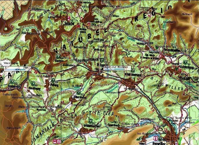
Thanks for the links.....some good maps....going to be difficult to find the right one for Wingen. Have to wonder how much the roads have changed since '45...Sure there are probably new ones.
Actually, the main road hubs have not changed at all, there are just a lot of new side roads:
http://maps.google.de/maps/place?ftid=0 ... _Abb9tXpBw
The river itself is not visible on google maps (sat images) anymore, just some man-made reservoirs, so the river may still exist, but they might have corrected its bed, and/or they built pipes/tunnels to gain more space for house construction. It was just a creek anyway.
Other than that, all the roads on the map from your first post are clearly visible, with minor changes.
On a sidenote, if you check the link above (click on the map on the right) and if you zoom in, you will see that the railway bridges aren't bridges, but rather tunnels (Rue Principale, Rue du Petit Passage, Rue Quartier Lalique). I marked 2 of them in the pic below.
Also, if you go to Google Earth (use the built-in Earth function on google maps, move the mouse pointer over the "Map" icon at the top right, then select "Earth"), then you'll see that the streets forming the rectangle-road network on the Heideneck hill really didn't change at all. Rue de Chateau d'Eau seems to be longer now and seems to join Rue de B.i.t.che (lol, that made me laugh here) further down the little hill, now.
Whatsoever, the following picture shows that the German unit "4" (4th Coy?) is sitting on the big hill (covered with woods) east of Heideneck, a perfect position for the defenders. It also shows that Heideneck looks like a little plateau with a hill top in the south of the rectangle road... another good position, then a gap north (with the northern road of the rectangle hub) and a way bigger hill up north. I can't see these features in your map.
Google maps and recent height maps for terrain visualization are ideal helpers, if you want to verify GSGS WW2 maps with contour lines... and your work in the map maker, of course.
The WW2 GSGS maps can be fairly inaccurate, by the way, as quite some of them are based on 1930s map material, oral descriptions, autobahn maps, maps from UK departments etc. (not kidding, the US department in charge had to do a lot of guesswork for quite some maps covering the French/BeNeLux/borders to Germany and Germany itself). Some map material issued to US unit commanders in France looked rather "white" (means there were almost no contour lines), hills or other vital landmarks were often missing.

- Attachments
-
- WingenFrance.jpg (197.58 KiB) Viewed 98 times
"Aw Nuts"
General Anthony McAuliffe
December 22nd, 1944
Bastogne
---
"I've always felt that the AA (Alied Assault engine) had the potential to be [....] big."
Tim Stone
8th of August, 2006
General Anthony McAuliffe
December 22nd, 1944
Bastogne
---
"I've always felt that the AA (Alied Assault engine) had the potential to be [....] big."
Tim Stone
8th of August, 2006
RE: Wingen Map Work
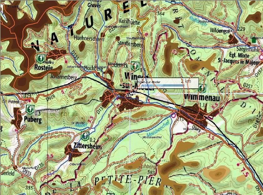
Good timing for your last post GoodGuy......I have just been sitting here trying to get started on another map of Wingen-sur-Moder. I am a bit afraid to start on it because I am not sure about what size of an area to cover for the scenario. I really do not want to get into a large map with 20 meter contour intervals. I am more inclined to do small maps and scenarios right now. The contours on the little map I made came from the same source as the modern day contour map I posted above. It is interesting that you noticed some terrain features that are really there and not on the little map I made. Hopefully I can draw up a map that is fairly accurate.Also will edit the railroad bridges....So easy to overlook some things...
Headquarters Company
422nd Regiment 106th Division
Sons of World War II Veterans
422nd Regiment 106th Division
Sons of World War II Veterans
RE: Wingen-sur-Moder Map
not kidding, the US department in charge had to do a lot of guesswork for quite some maps covering the French/BeNeLux/borders to Germany and Germany itself). Some map material issued to US unit commanders in France looked rather "white" (means there were almost no contour lines), hills or other vital landmarks were often missing.
[8D]
In our world of GPS, Google maps etc we have little sympathy for those of the 40's who had to use paper maps.
On the weekend I overheard a conversation about the 8th AF accidently bombing Nijmegen in Feb 44 and their target was Cleve (40km away?) A 5-6 minute delay or headwind and everything looks the same at 25,000ft.
In Burma, one of the Chindit column commanders reported the his men were "10 miles north of the P in UNEXPLORED" Dont recall if he got his supplies?
Same guy reported to Stilwell that they had taken umbrage, Reply comes in from the Staff that they cant find umpbrage on the map!
Interdum feror cupidine partium magnarum Europae vincendarum
RE: Wingen-sur-Moder Map
"The foremost cartographers of the land have prepared this for you. It's a map of the area that you'll be traversing... They'd be very grateful if you could just fill it in as you go along. ...Goodbye"
RE: Wingen Map Work
Here are a few screens showing where I am at on the larger map of the Wingen-sur-Moder area. I have the easy part done which is the roads streams and villages. The forest I will do last and will be easy also. I am now into the difficult part which is drawing the 20 meter contours.What a maze of contours! Going to take a while as it is tedious work and my eyes can only take looking at the underlay map for short periods of time. I am really not happy with using this map for an underlay but it is the best I can come up with right now.Hopefully I am not wasting my time.
Headquarters Company
422nd Regiment 106th Division
Sons of World War II Veterans
422nd Regiment 106th Division
Sons of World War II Veterans
-
Prince of Eckmühl

- Posts: 2459
- Joined: Sun Jun 25, 2006 4:37 pm
- Location: Texas
RE: Wingen Map Work
Hi Sweeteye,
I've found that when I make a map that I tend to do it in steps. Obviously, I go looking for a good contour map. If I'm lucky enough to find one, I do the map data and such, and then go to work on the contours themselves. In doing so, I establish the base-contour and then take care to limit the number of "islands," or areas that can't be drawn back to the corners of the map. Doing so saves me a lot of work, and the possibility that I'll foul the whole deal up. I can't use my hands in attempting to explain this to our readers, so let me post some screen-captures for clarifications sake.
I start with layer 1 which I draw on top of the base layer, or altitude 0. You'll notice that there are already some "islands, or areas that are isolated from the rest of the layer (which can be drawn back to a map edge). Again, whenever possible, I try to keep the islands to a minimum:
- Attachments
-
- layer1.jpg (58.69 KiB) Viewed 97 times
Government is the opiate of the masses.
-
Prince of Eckmühl
- Posts: 2459
- Joined: Sun Jun 25, 2006 4:37 pm
- Location: Texas
RE: Wingen Map Work
Then I add the next layer, again attempting to limit the number of islands. However, this is always a losing game as additional islands will indeed appear:

- Attachments
-
- layer2.jpg (63.04 KiB) Viewed 98 times
Government is the opiate of the masses.
-
Prince of Eckmühl
- Posts: 2459
- Joined: Sun Jun 25, 2006 4:37 pm
- Location: Texas
RE: Wingen Map Work
Adding altitude layer 3 yields additional islands. Again, this is a losing game as more islands appear! However, I've dramatically limited the amount of time that I spent on the layer immediately preceding this one:

- Attachments
-
- layer3.jpg (60.75 KiB) Viewed 97 times
Government is the opiate of the masses.
-
Prince of Eckmühl
- Posts: 2459
- Joined: Sun Jun 25, 2006 4:37 pm
- Location: Texas
RE: Wingen Map Work
Finally, with all the layers added, I have lots and lots of islands! Again however, by using the map edges to create what are essentially additional base layers, I limited the number of islands that I had to draw which are isolated from others of common altitude.

- Attachments
-
- layer15.jpg (92.67 KiB) Viewed 97 times
Government is the opiate of the masses.
-
Prince of Eckmühl
- Posts: 2459
- Joined: Sun Jun 25, 2006 4:37 pm
- Location: Texas
RE: Wingen Map Work
Finally, I go back and add all the other stuff. I try to finish a category before I go on, but I always fail in this regard. For that matter, I'm wide open to making changes to my maps. So long as I find map data that underpins the revision, I'm perfectly open to tinkering with them. I've never made a perfect map, and doubt that I ever will:

- Attachments
-
- Salernocomplete.jpg (186 KiB) Viewed 97 times
Government is the opiate of the masses.
RE: Wingen Map Work
Nice idea...seems like it would save some headaches.It would be interesting to see how it would work with the map I am working on.It is loaded with islands....lots of ravines ....twists and turns every which way....I may eventually expand the map to cover a larger area and will try your technique.I think I am going to remake the Omaha beach map so that might be a good one to try your method also...Thanks for posting the screens.....I am making some headway today on the Wingen map...about half done with the contours...picking up speed as I have made it through the initial contours....
Headquarters Company
422nd Regiment 106th Division
Sons of World War II Veterans
422nd Regiment 106th Division
Sons of World War II Veterans
-
Prince of Eckmühl
- Posts: 2459
- Joined: Sun Jun 25, 2006 4:37 pm
- Location: Texas
RE: Wingen Map Work
I suspect that you'll find more areas of equal altitude than might think. The main thing is to examine your bitmap underlay very carefully before you start laying polygons. But, that's equally true of doing your polygons, individually, as well.ORIGINAL: sweeteye
It would be interesting to see how it would work with the map I am working on.
And I realize that I forgot to mention something. If you look at the first or second images that I posted, it's important to realize that all of those layers except for the islands, all the big ones, are part of the same polygon. As I worked, I would lay part of the polygon. Then, when the layer reached the edge of the template, I'd extend the polygon along the edge until I reached another area of equal altitude, whereupon, the polygon would reach back out into the map. Except for perhaps ten small islands on that first image, the entire level 1 polygon is all connected. It's just a single, uninterrupted shape.
Government is the opiate of the masses.
RE: Wingen Map Work
PoE,
In general I agree with your approach. However, there's a potential problem with running a dummy contour line along the map edge. It's fine if it part of an area that extends into the map, but I would not recommend running the contour line alomg the edge just for the sake of keeping everything as one big poly. Such a "dummy" line can affect the spot height calcs done on the location near the map edge. Eg if you run a one or more contour lines along a map edge of say 80m and 100m over what really is 0m height, then there is the potential to skew the spot heights along the map edge so they are higher than 0m.
In general I agree with your approach. However, there's a potential problem with running a dummy contour line along the map edge. It's fine if it part of an area that extends into the map, but I would not recommend running the contour line alomg the edge just for the sake of keeping everything as one big poly. Such a "dummy" line can affect the spot height calcs done on the location near the map edge. Eg if you run a one or more contour lines along a map edge of say 80m and 100m over what really is 0m height, then there is the potential to skew the spot heights along the map edge so they are higher than 0m.
-
Prince of Eckmühl
- Posts: 2459
- Joined: Sun Jun 25, 2006 4:37 pm
- Location: Texas
RE: Wingen Map Work
ORIGINAL: Arjuna
PoE,
In general I agree with your approach. However, there's a potential problem with running a dummy contour line along the map edge. It's fine if it part of an area that extends into the map, but I would not recommend running the contour line alomg the edge just for the sake of keeping everything as one big poly. Such a "dummy" line can affect the spot height calcs done on the location near the map edge. Eg if you run a one or more contour lines along a map edge of say 80m and 100m over what really is 0m height, then there is the potential to skew the spot heights along the map edge so they are higher than 0m.
Thanks Dave, I'll keep an eye out for that.
BTW, have you ever made note of the fact that an altitude "0" layer is always Z=0m at a map edge even if it might not be IRL? I realize that it's just a limitation of the engine, but it does sort of jump out at you when you come across it! Obviously, the effect can be ameliorated by using smaller altitude increments. But, using 50m+ increments, the results can be pretty dramatic.
Question for you...
Has there ever been any discussion about the possibility of adding curvature to the top layer of a polygon? As is, the top layer is always flat, which is fine, but it would seem to have LOS implications.
Government is the opiate of the masses.